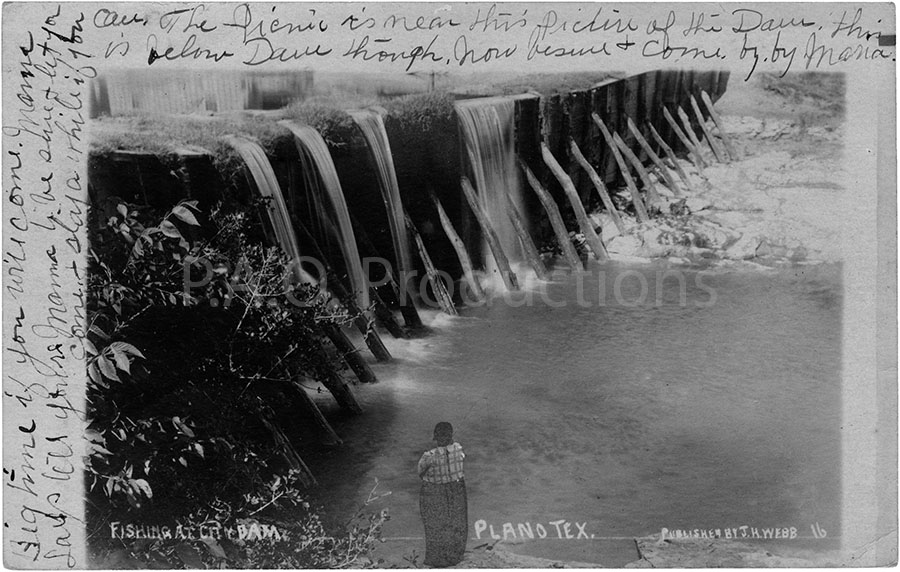
It had never occurred to me that the city of Plano would ever have or need a dam. Today, Plano is a largely urbanized yet somewhat dichotomous suburb of Dallas, with some areas remaining older and less affluent and others filled to the brim with corporate campuses and cookie-cutter style apartment complexes and shopping centers. I was aware of the city's largely rural past - even in my teenage years of the late 1990s there were still some notably undeveloped areas - but a dam? I couldn't picture a dam in Plano, and I couldn't imagine where it would have been. So I decided I would try to find it.
Initially, my efforts proved largely fruitless. The writing on the postcard, which bears a postmark of August 1907, gave no clue as to the dam's location, with the sender referencing only a future picnic location that was nearby. My usual sources - that is to say, historical newspaper articles and advertisements and online searches - all came up 99% empty. The best I was able to turn up were an April 1900 Dallas Morning News reference to the dam having overflowed, one or two references to people visiting the area, and a handful of references to bond sales being proposed to fund the dam and adjoining waterworks facility. Nearly all were from the first decades of the 20th century, but none referenced the actual exact location of the dam. Presumably, with Plano being such a small community of around 1,300 people at the time of the postcard, it was assumed that readers would already know how to find it. I pored over maps of Collin County, trying to decide if any of the lakes still present in the area might once have been the source of a water flow powerful enough to necessitate the structure seen in the old photo. None seemed promising.
Eventually, an online search teased the promise of a lead when, after what seemed like interminable digging through online spaces, I stumbled upon another photo of the dam... or, should I say, of the Plano waterworks. The image came from another RPPC held by the Plano Public Library, and it was (and is) listed on their website via their Collin County Images collection. Apparently the postcard was part of a much larger assemblage of historic memorabilia intended to document the founding, early days, and development of the city of Plano. In theory, I could contact the Genealogy department, tell them of my search, and ask for access to those archives. But I didn't need to examine any original photos; I just needed to know where one of them was taken, if possible. So one Monday in early August I drove out to the Haggard Library branch off Coit Road, my original postcard in hand, and paid the Genealogy department a visit. I spoke with Isha, who then referred me to Tre, one of their senior staff members, and together the three of us consulted old print maps, reference publications, the internet, anything that might provide a clue to the original location of the waterworks. I was shown a large collection of local records on microfilm, which are unfortunately not yet digitized, making them of limited utility for someone searching for the answer to a riddle on what was essentially a lark. Isha suggested that maybe the waterworks were at present-day Harrington Park, but we couldn't find anything definitive. Tre and I looked at Big Lake Park as another potential match, but no dice there, either. Finally, Tre phoned Cheryl Smith, the curator of the library's memorabilia holdings. She knew exactly where it was: at the current location of the Sam Johnson Recreation Center off 16th Street... at Harrington Park.
About two weeks later, my friend Alex and I drove out to Plano to have a look in person. This was initially planned as more of a reconnaissance mission than an attempt to get a definitive photo; the temperature peaked at 96 degrees that day, and it was too hot during the afternoon to spend time playing with camera settings and potentially trying to find a good angle. We went very late in the evening, such that the ray of the sun wouldn't beat down on us with full force; I had already reconnoitered the site via Google Maps' street view, and thus knew what I was looking for. We parked at the rec center and walked about 300 feet down 16th Street to the bridge, arriving at the predetermined spot. After taking some photos and recording a little bit of video footage, we departed as the light of the evening faded into dusk.
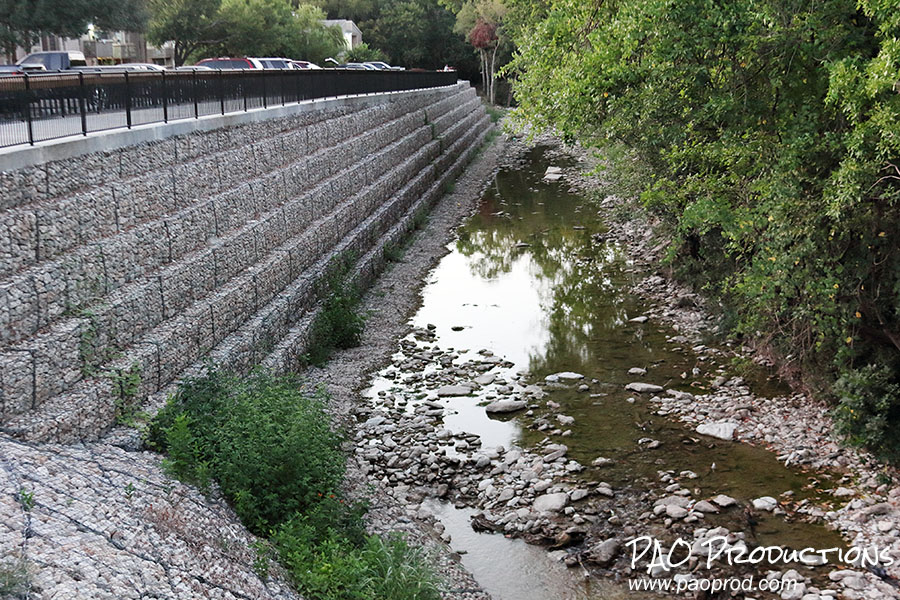
All that remained was to write up my experiences into this blog post and move on to other projects. But something wasn't sitting right with me. I had assumed that the view on the original postcard was facing north, as it pictured a precipitous drop off of water into the creek on the left side, and the only such drop off today was the wall separating Harrington Park from the apartment complex to the west. Surely the builders had simply bricked it up when the complex was constructed. But the more I thought about it, the more I came to believe that my initial assumption had been incorrect. The location of the waterworks facility was said to be near the present-day location of the rec center, which would place it on the east side of the creek, and thus on the north side of today's 16th Street. And based on the orientation of the facility and dam in the library image, that would mean that the original photographer's perspective was actually facing south. We would need to go back and try to re-shoot the Creek from the other side.
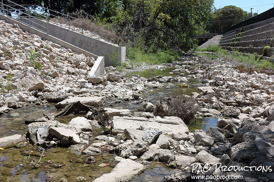
Armed with this new information, Alex and I returned to the site three weeks after our first visit and walked down the adjacent Chisholm Trail, on the lookout for a suitable vantage point. We were able to (very carefully!) descend down to the water level, where I was able to get the south facing photograph below. Is this the exact location shown in the original postcard? There's no way to know for sure, but I think that the new view is at the very least a good approximation of what the original site looks like more than a century later. Remnants of the original water system are said to remain today, so this seems to be as good a vantage point as any. The city of Plano constructed the waterworks site to supply water to the city, but the once mighty Spring Creek has now been reduced to a mere trickle compared to what once was. How things have changed in 117 years.
I’m sure, in all your research, you found reference to the problems encountered when the original Collin Creek Mall was constructed in the late 70’s. More than once, sinking occurred because of deterioration from underground streams. This would have been just south of the site you explored. I found your article very interesting and appreciate the time and effort you expended.
I actually confined my efforts to the dam and waterworks and not to the general location, but it makes sense that sinking would have occurred in the area. One of the things I discovered about Plano is the number of these underground streams that exist. It’s definitely apparent when you look at an old map. Thanks for the added context!
Hi Peter,
The Dam was located VERY near the 16th Street Bridge over Spring Creek.
I have posted about it several times on the Facebook Group
Plano History (& Nostalgia)
https://www.facebook.com/groups/1592137491015058/permalink/3237727863122671
That group never came up during my efforts to research the dam, but I’m pleased to know that we pretty much nailed the location. Thanks for the confirmation!