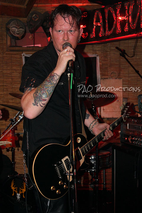
bookmark_borderEmma Lucore follow up: Visiting the old locations in 2025

Emma Lucore's first Fort Worth studios were at 109 E 3rd Street, next door to the original Fort Worth Opera House, and at 808 Main Street, one block north of husband Bassett's wood and coal yard. Both these original studio locations are still in use today by active businesses. I paid a few visits to the area to get a look at the sites as they stand in the 21st century. On one of my visits, I was accompanied by a friend.
1889 Sanborn insurance map detail
Detail of 1889 Sanborn insurance map, recording the Fort Worth Opera House and photo studio next door
Continue reading "Emma Lucore follow up: Visiting the old locations in 2025"

bookmark_borderEmma J. Lucore, early Fort Worth photographer

Lucore & Ward Opera Studio cabinet card imprint

(Update: I visit the old Fort Worth studio locations in this follow up post)

If you're a follower of this blog and website, you know that one of my interests is photography, both contemporary and historical. I've featured several collections of vintage and antique photos alongside my own, and I'm currently in the midst of a longish-term project to chronicle the histories of early local photographers. Toward this end, about five months ago, I began assembling a collection of Fort Worth-area cabinet cards. These included works by Burdge, Daniel, Mignon, Swartz, Thomason & Leffler, Works, and one of my rare acquisitions from a female photographer, Emma Lucore. I'd never heard of Emma Lucore before then, and I decided to have a look into who she was and how long her studio was in operation.

Continue reading "Emma J. Lucore, early Fort Worth photographer"

bookmark_borderVantage points for photographing the Dallas skyline

Photographing nighttime skylines is one of my favorite pursuits when I go out with my camera. On many of my road trips across both the United States and Canada, I've tried to do this whenever possible, and I've captured both partial and full skylines in cities such as Vancouver, Montreal, Edmonton, Detroit, Philadelphia, and New York. Closer to home, I've spent a good amount of time looking for the best vantage points in the Dallas area to capture a good view of the Downtown skyline, and I'm presenting several of those here. These are spots where it's practical for a normal person to take a photo, and the places listed below are all easily accessible without a lot of effort.

N. Edgefield Avenue bridge over Interstate 30

A great place to capture the full Dallas skyline is on North Edgefield Avenue over Interstate 30, just south of Fort Worth Avenue. Not only does this location give one of the best views of the skyline, it also offers a chance to get some cool light trails at night via a long exposure. And, unlike some of the other spots on this list, it provides a view of Downtown which includes Reunion Tower.

This area feels a bit sketchy, so if you're doing night shooting it might not be a bad idea to take along a companion to watch your back.

Continue reading "Vantage points for photographing the Dallas skyline"

bookmark_borderLate 1800s street map of Dallas

Some time ago I acquired this original copy of a map of early Dallas. The map was advertised as being from 1902, but the streets as laid out are more indicative of Dallas in the late 1880s. The map shows not only the layout of Dallas's road system as it existed in the late 19th century, but also shows the original names of a great number of streets before subsequent changes were made over succeeding decades. Sycamore north of Commerce Street hasn't yet been renamed to Akard, and Carondelet north of Pacific Avenue, by the Trinity River, hasn't yet been renamed as an extension of Ross Avenue. Present-day Record Street still shows as Jefferson, Ervay Street is still Oleander north of Pacific Avenue, and the route of present-day Saint Paul Street still exists as Masten and Evergreen Streets. Streets that are long gone, such as Calhoun and Walnut Streets north of Carondelet, are depicted. And there are also some slight inaccuracies: for example, Harwood is amusingly misspelled as "Hardwood" south of Commerce Street. Lastly, you can see the original alignment of the Trinity River before its relocation and straightening in 1928. Oak Cliff, Dallas's then-sister city and not yet annexed, is not represented.

The map page, which has a map of San Francisco on the other side, was one page of what was clearly a larger volume. It's likely that the same map was reproduced year after year in whatever volume this was (assuming it was a recurring collection). Thus, it's possible that my particular copy does indeed date to 1902. Without seeing the entire collection, I can't be sure.

You can download this scan in a larger size here. I've also uploaded it to the Internet Archive in an extra large size.

I believe this type of historical information should be made easily available and accessible to the public, not barricaded behind paywalls or hoarded behind closed doors by museums, archives, and collectors.


All original material on this page is © 2025 Peter Orozco (all rights reserved).