The adventures and various works of a photographer, road tripper, former patron of the local arts, aspiring app developer, and late night coffee drinker and conversationalist.
Here is a collection of rare and mostly one-of-a-kind photos from the Dallas area, most of them from my personal collection. These recall a bygone era in Dallas public transportation, with a focus on showcasing still identifiable areas of the city that have changed significantly since the original images were taken. Vintage streetcar photos can be some of the best representations of what once existed downtown, offering unique glimpses of long-gone city blocks, buildings, and intersections.
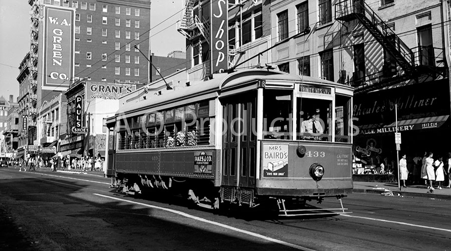
View facing east on Elm Street near Stone Place, circa 1943
This medium format film negative captures a very different view from what is seen today. The Rhealee Milliner on the right side of the picture is now the City Tavern, and the shorter building on the left that housing Paul's Shoes is completely gone, its place now occupied by a parking lot. Today the Giant Eyeball resides in the space next to that parking lot, looking out toward Main Street one block south and marking the farther end of the lot where the old Praetorian building, Dallas' first skyscraper, stood before being demolished in 2013.
Elm Street at Stone, facing east, circa 1943 (Author's collection)Continue reading "Dallas’s interurban streetcars in vintage photographs"
New York-born photographer Arthur Rothstein made a name for himself with his many series of photos documenting America. His long career earned him recognition for his work as a photojournalist, author, and teacher, but it is perhaps his Great Depression era work, undertaken at the behest of the U.S. Farm Security Administration, for which he is best remembered today. In 1942, this assignment brought him to North Texas and to the old Fort Worth-Dallas Highway, where his photographer's eye led him to capture a string of period businesses and landmarks along the way. These images would become important historical records of their period in history, all of them eventually seeing reproduction on prints, postcards, and historical publications and websites time and time again in the decades since.
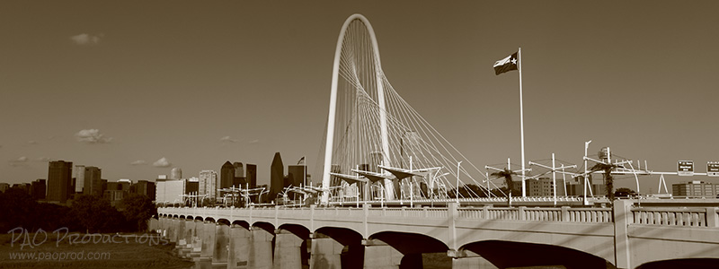
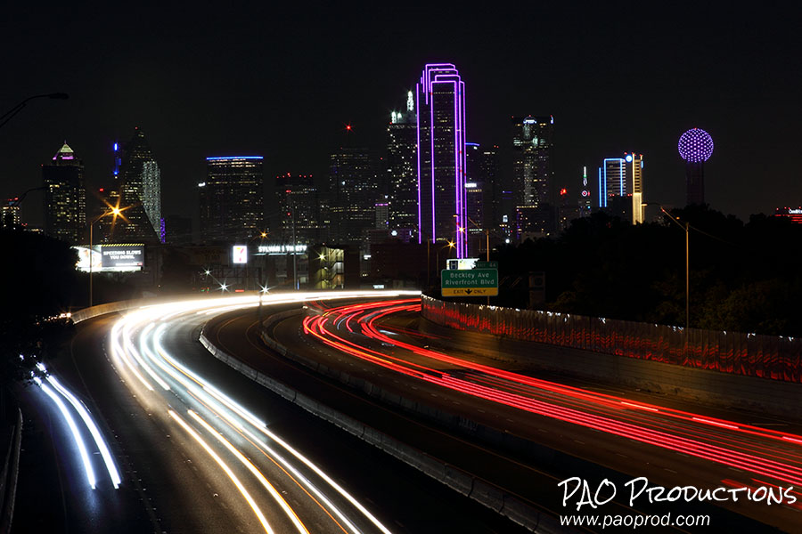
Photographing nighttime skylines is one of my favorite pursuits when I go out with my camera. On many of my road trips across both the United States and Canada, I've tried to do this whenever possible, and I've captured both partial and full skylines in cities such as Vancouver, Montreal, Edmonton, Detroit, Philadelphia, and New York. Closer to home, I've spent a good amount of time looking for the best vantage points in the Dallas area to capture a good view of the Downtown skyline, and I'm presenting several of those here. These are spots where it's practical for a normal person to take a photo, and the places listed below are all easily accessible without a lot of effort.
N. Edgefield Avenue bridge over Interstate 30
A great place to capture the full Dallas skyline is on North Edgefield Avenue over Interstate 30, just south of Fort Worth Avenue. Not only does this location give one of the best views of the skyline, it also offers a chance to get some cool light trails at night via a long exposure. And, unlike some of the other spots on this list, it provides a view of Downtown which includes Reunion Tower.
This area feels a bit sketchy, so if you're doing night shooting it might not be a bad idea to take along a companion to watch your back.
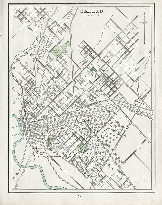
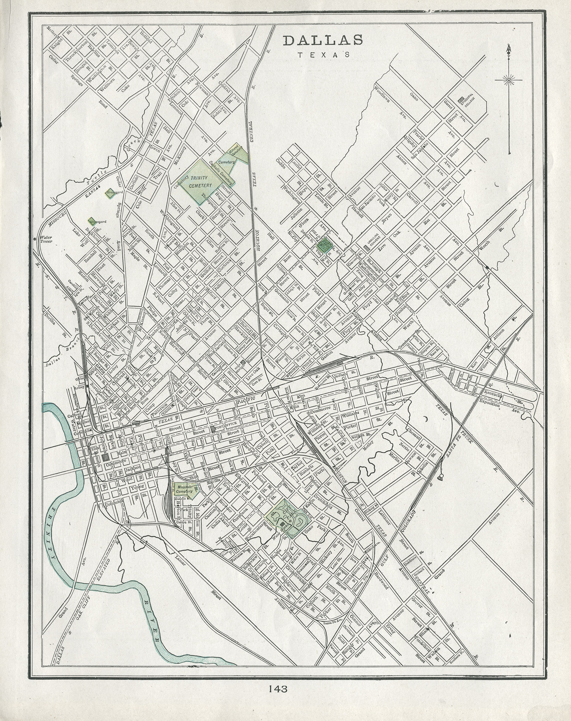
Some time ago I acquired this original copy of a map of early Dallas. The map was advertised as being from 1902, but the streets as laid out are more indicative of Dallas in the late 1880s. The map shows not only the layout of Dallas's road system as it existed in the late 19th century, but also shows the original names of a great number of streets before subsequent changes were made over succeeding decades. Sycamore north of Commerce Street hasn't yet been renamed to Akard, and Carondelet north of Pacific Avenue, by the Trinity River, hasn't yet been renamed as an extension of Ross Avenue. Present-day Record Street still shows as Jefferson, Ervay Street is still Oleander north of Pacific Avenue, and the route of present-day Saint Paul Street still exists as Masten and Evergreen Streets. Streets that are long gone, such as Calhoun and Walnut Streets north of Carondelet, are depicted. And there are also some slight inaccuracies: for example, Harwood is amusingly misspelled as "Hardwood" south of Commerce Street. Lastly, you can see the original alignment of the Trinity River before its relocation and straightening in 1928. Oak Cliff, Dallas's then-sister city and not yet annexed, is not represented.
The map page, which has a map of San Francisco on the other side, was one page of what was clearly a larger volume. It's likely that the same map was reproduced year after year in whatever volume this was (assuming it was a recurring collection). Thus, it's possible that my particular copy does indeed date to 1902. Without seeing the entire collection, I can't be sure.
You can download this scan in a larger size here. I've also uploaded it to the Internet Archive in an extra large size.
I believe this type of historical information should be made easily available and accessible to the public, not barricaded behind paywalls or hoarded behind closed doors by museums, archives, and collectors.